
Natural wonders, sculpted by geological forces over millennia, offer profound experiences. These five locations represent a fraction of Earth’s remarkable landscapes, each providing a unique perspective on natural processes and the planet’s vast scale. Consider these destinations for their geological significance, ecological diversity, and aesthetic impact.
The Grand Canyon, Arizona, USA
The Grand Canyon, carved by the Colorado River, is a chasm approximately 277 miles (446 km) long, up to 18 miles (29 km) wide, and over a mile (1.8 km) deep. Its sheer scale challenges comprehension. Erosion has exposed layers of rock dating back nearly two billion years, making it a geological library.
Geological Formation
The canyon’s formation is a complex narrative spanning geological eras. The uplift of the Colorado Plateau, beginning roughly 70 million years ago during the Laramide Orogeny, provided the gravitational potential for the Colorado River to incise the land. Subsequent erosion, driven by water and wind, progressively deepened and widened the canyon. The earliest rock layers visible at the bottom of the canyon, known as the Vishnu Basement Rocks, are metamorphic and igneous, formed during the Precambrian era. These are overlain by a sequence of sedimentary rocks, each layer representing a different ancient environment, from shallow seas to sand dunes. The concept of “deep time” becomes tangible when observing these strata.
Ecological Zones
The Grand Canyon supports diverse ecological zones, reflecting variations in elevation, aspect, and microclimates. The canyon’s depth creates a series of life zones, akin to traveling from Mexico to Canada in terms of vegetation and animal life.
Riparian Zones
Along the Colorado River, the riparian zone thrives, characterized by willows, cottonwoods, and abundant insect life. This narrow strip is a lifeline for numerous bird species and mammals that depend on the water source in an otherwise arid environment.
Desert Scrub
Immediately above the river, desert scrub dominates, featuring plants adapted to aridity, such as sagebrush, brittlebush, and various cacti. Animals here include lizards, snakes, and small mammals like kangaroo rats.
Pinyon-Juniper Woodland
As elevation increases, pinyon-juniper woodlands appear, characterized by stunted trees and more diverse undergrowth. This zone supports mule deer, coyotes, and various raptors. Pinyon pines produce edible nuts, a traditional food source for indigenous peoples.
Ponderosa Pine Forest
At the highest elevations, particularly on the North Rim, ponderosa pine forests flourish. These areas receive more precipitation and support larger mammals like elk and black bears. The cooler temperatures and increased moisture create a distinct forest ecosystem.
Visitor Experiences
Access to the Grand Canyon is primarily via its South Rim and North Rim, each offering distinct perspectives and visitor amenities.
South Rim
The South Rim is the more accessible and developed area, open year-round. It offers numerous viewpoints, such as Mather Point, Yavapai Point, and Grandview Point. The Bright Angel Trail and the Hermit Trail are popular hiking routes into the canyon, offering an immersive experience for those prepared for strenuous elevation changes. Lodging, restaurants, and visitor centers are concentrated here.
North Rim
The North Rim is higher in elevation, receives more snow, and is typically open from mid-May to mid-October. It offers a more secluded experience with fewer visitors. Views from the North Rim tend to be more panoramic, looking down into a broader expanse of the canyon. Point Imperial and Cape Royal are notable viewpoints. Hiking trails here, such as the North Kaibab Trail, also descend into the canyon.
Mount Everest, Nepal/Tibet (China)
Mount Everest, known as Sagarmatha in Nepali and Chomolungma in Tibetan, is Earth’s highest mountain above sea level, reaching an elevation of 8,848.86 meters (29,031.7 feet). Its sheer prominence makes it a global landmark and a symbol of human aspiration.
Geological Uplift
Everest is part of the Himalayas, a mountain range formed by the collision of the Indian and Eurasian tectonic plates. This ongoing collision, which began approximately 50 to 60 million years ago, continues to uplift the range, pushing Everest higher by a few millimeters per year. The rocks comprising Everest’s summit are marine limestones and sandstones, clear evidence of their oceanic origin before being thrust skyward. This process illustrates the dynamic nature of Earth’s crust as a vast, slow-motion sculptor.
Extreme Environment
The environment on Everest is characterized by extreme cold, high winds, and significantly reduced atmospheric pressure, often referred to as “the death zone” above 8,000 meters.
High Altitude Physiology
The lower oxygen levels at extreme altitudes pose significant physiological challenges. The partial pressure of oxygen at Everest’s summit is only about one-third that at sea level, requiring specialized acclimatization and often supplemental oxygen for climbers. Acute mountain sickness, high-altitude cerebral edema, and high-altitude pulmonary edema are significant risks.
Weather Patterns
Everest’s weather is notoriously unpredictable, dominated by strong winds, blizzards, and temperatures that can drop to -60°C (-76°F). The mountain creates its own weather systems, and the “jet stream,” a ribbon of high-altitude winds, often descends to brush the summit, making ascents impossible during these periods. The climbing window is typically short, usually in May before the summer monsoon and sometimes in autumn after it.
Cultural and Spiritual Significance
For the Sherpa people of Nepal and Tibetan Buddhists, Everest (Chomolungma) is a sacred mountain, often referred to as “Mother Goddess of the Earth.”
Sherpa Culture
The Sherpa people have inhabited the Everest region for centuries, developing unique adaptations to the high-altitude environment. Their deep knowledge of the terrain and their physical endurance have made them indispensable to mountaineering expeditions. Their culture is intertwined with the mountains, and they hold strong spiritual beliefs regarding the sacredness of the peaks.
Buddhist Traditions
Buddhist monasteries, prayer flags, and mani stones (stones inscribed with prayers) are common throughout the region, reflecting profound spiritual reverence for the mountains. Pilgrimages to sacred sites within the Everest region are also a significant aspect of Buddhist practice.
The Great Barrier Reef, Queensland, Australia
The Great Barrier Reef is the world’s largest coral reef system, composed of over 3,000 individual reefs and 900 islands stretching for over 2,300 kilometers (1,400 miles) along the coast of Queensland, Australia. It is a living marine masterpiece, a kaleidoscope of life beneath the waves.
Coral Reef Ecology
Coral reefs are intricate underwater ecosystems built by colonies of tiny marine invertebrates called polyps. These polyps secrete calcium carbonate to form hard exoskeletons, which, over millennia, accumulate to create massive reef structures. The reef is a biological architect, shaping its own environment.
Symbiotic Relationship
Corals have a symbiotic relationship with microscopic algae called zooxanthellae, which live within their tissues. The algae perform photosynthesis, providing the corals with essential nutrients, while the corals provide the algae with protection and compounds necessary for photosynthesis. This relationship is fundamental to the reef’s health and vibrant colors.
Biodiversity Hotspot
The Great Barrier Reef boasts unparalleled biodiversity, supporting an estimated 10% of the world’s fish species, over 30 species of marine mammals (including whales, dolphins, and dugongs), six species of sea turtles, and numerous species of mollusks, echinoderms, and other invertebrates. It is a nursery and feeding ground for countless marine organisms.
Environmental Threats
The Great Barrier Reef is facing significant environmental threats, primarily from climate change and human activities.
Climate Change
Rising ocean temperatures cause coral bleaching, where corals expel their zooxanthellae, leading to coral starvation and death if temperatures remain elevated. Ocean acidification, caused by increased absorption of atmospheric carbon dioxide, reduces the availability of carbonate ions, making it harder for corals and other calcifying organisms to build their skeletons. These are existential threats, subtly dismantling the reef’s architecture.
Localized Impacts
Other threats include poor water quality from agricultural runoff, which carries sediments and nutrients that promote algal growth, outcompeting corals. Overfishing can disrupt the delicate balance of the reef ecosystem, while marine debris and physical damage from anchoring or tourism also contribute to degradation.
Conservation Efforts
Numerous conservation efforts are underway to protect the Great Barrier Reef, spanning local, national, and international scales.
Marine Park Zoning
The Great Barrier Reef Marine Park Authority manages the reef through a comprehensive zoning plan, which designates areas for different uses such as general use, habitat protection, and “no-take” zones with strict prohibitions on fishing and collecting. This acts as a protective shield against immediate pressures.
Scientific Research
Extensive scientific research is conducted to monitor the reef’s health, understand the impacts of various threats, and develop strategies for restoration and resilience. This includes research into coral genetics, rehabilitation techniques, and climate-resilient coral species.
Public Awareness
Education and public awareness campaigns are crucial to foster stewardship and support for conservation initiatives. Promoting sustainable tourism practices and reducing individual carbon footprints are vital components of broader conservation efforts.
The Amazon Rainforest, South America
The Amazon Rainforest, a vast expanse of tropical forest covering approximately 6.7 million square kilometers (2.6 million square miles), primarily within nine South American countries, represents the world’s largest remaining rainforest. It is a crucial planetary regulator, a living, breathing lung for Earth.
Unparalleled Biodiversity
The Amazon is recognized as the most biodiverse terrestrial ecosystem on Earth. It harbors an estimated 10% of the world’s known species, with new species continually being discovered. This rich tapestry of life includes an astounding array of flora and fauna.
Plant Species
The Amazon is home to approximately 16,000 tree species, making up a significant portion of the world’s tropical trees. Many of these plants possess medicinal properties, some of which are only now being identified and studied. The sheer density of vegetation is a powerful engine of biodiversity.
Animal Species
Millions of insect species, thousands of bird species, reptiles, amphibians, and mammals inhabit the Amazon. Iconic species include jaguars, anacondas, monkeys, sloths, and countless varieties of birds like macaws and toucans. The intricate web of predator and prey, herbivore and plant, defines the ecosystem.
Ecological Importance
The Amazon’s ecological importance extends far beyond its borders, influencing global climate and hydrological cycles.
Climate Regulation
The rainforest plays a vital role in regulating global climate by absorbing vast amounts of carbon dioxide through photosynthesis, acting as a significant carbon sink. Deforestation releases this stored carbon back into the atmosphere, contributing to climate change.
Hydrological Cycle
The Amazon is a critical component of the global hydrological cycle. Through evapotranspiration, billions of tons of water are released into the atmosphere daily, creating “flying rivers” that transport moisture across the continent, influencing rainfall patterns in distant regions. The forest essentially recycles its own weather.
Threats and Conservation
The Amazon faces severe threats, primarily from deforestation, driven by agriculture, logging, and mining.
Deforestation Drivers
Cattle ranching is the single largest driver of deforestation in the Amazon, followed by soybean cultivation, illegal logging, and mining operations. Infrastructure projects such as dams and roads also fragment the forest and open it to further exploitation.
Indigenous Land Rights
Indigenous communities, who have lived in the Amazon for millennia, are vital custodians of the rainforest. Their traditional knowledge and sustainable practices have historically protected vast areas. Recognizing and strengthening their land rights is a crucial conservation strategy, as their territories often exhibit lower deforestation rates.
International Efforts
International organizations and governments are working to combat deforestation through initiatives that promote sustainable land use, combat illegal logging, and provide financial incentives for forest conservation. However, the scale of the challenge requires sustained, coordinated global action.
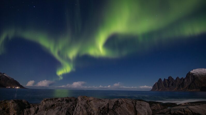
The Northern Lights (Aurora Borealis), Arctic Regions
The Northern Lights, or Aurora Borealis, is a celestial phenomenon characterized by dynamic displays of colored light in the sky, primarily observed in high-latitude regions around the Arctic Circle. It is a ethereal drama played out in Earth’s upper atmosphere.
Scientific Explanation
The aurora is a natural light display in Earth’s sky, predominantly seen in high-latitude regions. It is caused by the collision of energetic charged particles with atoms in the high altitude atmosphere.
Solar Wind Interaction
The aurora begins with the sun. The sun constantly emits a stream of charged particles known as the solar wind. When this solar wind interacts with Earth’s magnetosphere – the protective magnetic bubble surrounding our planet – some of these particles become trapped and accelerated along magnetic field lines towards the polar regions.
Atmospheric Collisions
As these energetic particles enter Earth’s upper atmosphere, typically at altitudes between 80 and 500 kilometers (50 and 300 miles), they collide with atmospheric gases, primarily oxygen and nitrogen atoms. These collisions excite the atoms, causing them to emit photons of light. The specific color of the auroral display depends on the type of gas atom and the energy of the colliding particle.
Colors of the Aurora
Green is the most common auroral color, produced by excited oxygen atoms at lower altitudes (around 100-200 km). Red auroras, less common but spectacular, result from oxygen atoms at higher altitudes (above 200 km). Nitrogen atoms produce blue or purple light, often seen at the lower edges of auroral displays. The sky becomes a vast, dynamic canvas of electromagnetic energy.
Best Viewing Locations
While the aurora can occasionally be seen at lower latitudes during intense solar storms, the most reliable and spectacular displays occur within the “auroral oval,” a band around the magnetic poles.
Northern Scandinavia
Regions like Northern Norway (Tromsø, Lofoten Islands), Sweden (Abisko), and Finland (Lapland) are prime viewing locations. These areas offer a combination of high latitude, clear skies, and developed infrastructure for tourism.
Iceland
Iceland, situated just below the Arctic Circle, is another popular destination. Its easily accessible wilderness areas and numerous opportunities for combining aurora viewing with other natural attractions make it attractive.
Canada and Alaska
In North America, locations such as Yellowknife in Canada’s Northwest Territories and Fairbanks in Alaska are renowned for consistent aurora sightings. These regions often offer darker skies due to less light pollution.
Optimal Viewing Conditions
Observing the aurora requires specific conditions, a confluence of celestial mechanics and earthly weather.
Dark Skies
Minimal light pollution is crucial. City lights can easily mask fainter aurora displays. Seeking out remote locations away from urban centers significantly enhances the viewing experience.
Clear Weather
Cloud cover is the primary enemy of aurora viewing. Clear, cloudless skies are essential to see the lights. Therefore, checking weather forecasts is an integral part of planning an aurora chase.
Magnetic Activity
The strength of the aurora is directly related to solar activity, specifically the intensity of geomagnetic storms. Websites and apps dedicated to aurora forecasting provide predictions of planetary K-indexes (Kp-Index), which indicate the likelihood and intensity of auroral displays on a given night. Higher Kp values indicate a greater chance of seeing the aurora, and potentially a more widespread and vibrant display.